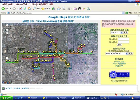
(论文 字数:27367页数:67 带程序)摘要:为提高城市公交对乘客出行的吸引力,为乘客的公交出行提供准确、及时、优化的公交信息服务,本文基于北京市公交基础信息和公交乘客出行的特点,综合利用WEB GIS开发技术设计开发了北京市公交查询系统。该系统是在Google 提供的免费地图Google Maps的基础上,利用Access描述、创建了公交线网的数据存储结构,并采用ASP作为开发工具利用ADO与Database Server连接访问,实现了对公交线网及公交站点的数据信息管理和查询。在客户端通过Javascript语言调用google Maps API,在浏览器中的Google Maps上显示公交线路和车站及其相关信息。
该系统设计具有公交线路查询、公交站台查询及具有最少换乘次数的公交换乘查询等功能,并可将这些功能的查询结果在Google Maps上显示,为乘客的公交出行提供准确、及时、优化的公交信息服务和出行辅助计划。
本文还介绍了当前流行的网站开发技术Ajax,并在本系统中尝试实现。本系统所采用的开发技术都是目前刚刚兴起且较流行的技术,是今后Web GIS 开发的方向之一,就有一定的创新性。
关键词 :Web GIS,Google Maps(API),公交,查询,换乘;
Abstract :This article, which is based on the public transportation element information of city of Beijing and the character of bus passenger travel, designs and opens out Beijing public transportation guiding system, to improve the appeal from city public transportation to passengers' traveling and provide service of exact, in time and improved public transportation information. The system is based on free map named as Google Maps provided by Google, using Access to describe and construct the data storage structure of public transportation networks, and also making use of ASP’S ADO as an exploitation tool to connect and visit Database Server, realizing the management and inquiry of public transportation routes and their stations' data information. This system achieves such functions as following, by transferring Google Maps API, using JavaScript as its language, in customer port it will show bus route, stations and other information in the Browser.
With this systematic design you can achieve bus route inquiry, bus station inquiry, the least transfer number inquiry of city bus and other functions, at the same time showing these results on Google Maps, as a result, offering exact, in time and improved city bus information service and assistant traveling plan.
This article also introduces present popular web development technology Ajax, trying to make it come true. The development technology used in this system is springing up recently and popular, and is one of the development directions in future, which makes itself creative.
Key Words: Web GIS; Google Maps (API); public transportation; inquiry; transfer
目录
摘要
Abstract
目录
第1章 绪论 1
1.1 研究背景 1
1.2 本文研究的问题 3
1.3 本文完成的工作 3
第2章 基于GOOGLE MAPS的城市公交查询系统实现的关键技术 5
2.1 引言 5
2.2 基于GOOGLE MAPS的城市公交查询系统实现的关键技术 5
2.2.1 Web开发技术 5
2.2.2 Google Maps API 10
2.2.3 数据库技术 11
2.3 WEB开发工具 11
2.4 本章小结 12
第3章 系统总体结构设计 13
3.1 系统网络的软件体系结构选择 13
3.2 系统总体结构图 13
第4章 系统详细设计及实现 14
4.1 引言 14
4.2 本文所使用GOOGLE MAPS API介绍 14
4.3 界面设计 18
4.4 数据库设计及实现 18
4.4.1 数据库库表结构设计 19
4.4.2 数据库联接 20
4.5 地图加载及系统功能模块设计 21
4.5.1 将Google Maps在系统中显示 21
4.5.2 系统加载时在Google Maps上显示公交线路、公交站点及其相关信息 22
4.5.3 公交站点查询 27
4.5.4 公交线路查询 27
4.5.5 公交换乘 29
4.6 AJAX技术在本系统的尝试 34
第5章 结论与展望 36
参考文献 37
外文翻译 39
致 谢 56
第1章 绪论
1.1 研究背景
自从上世纪六十年代世界上第一个GIS诞生以来,GIS如“星星之火”迅速发展;到如今,地理信息系统正形成完整的技术系统并逐渐地建立其独立的理论体系。它的应用渗透于社会的各个领域,已从传统的自然资源管理、土地规划等领域扩展到交通、军事、商业等非常广泛的领域,并取得了巨大的经济效益。然而,计算机软、硬件技术和全球信息网络技术的发展是如此之快,使得GIS技术也受到了巨大的冲击,随着第三代能提供基于Web的联机事务处理能力的Web技术的出现,Com GIS和Web GIS应运而生,标志着GIS系统集成技术的发展进入了一个崭新的阶段。
|